
Lidar Mapping Services
Published by
LIDAR
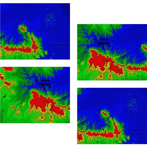
Laser scanning allows spatial measurements thanks to capturing of a laser beam reflection. This method gives us information on the structure and 3D position of registered objects. The resulting point cloud can have varied density (from several up to several dozens points/m²). Each point is rectified to a system of geodetic coordinates and then classified according to client’s desired schema. The final product may be a point cloud, DTM, DSM, 3D model or visualisation. ALS helps when you need to know the size and shape of an object or to see and model surfaces under tree canopy.
Lidar Mapping Services
Feiyan Technology focus on offerring high accuracy Lidar Mapping Services. Lidar, which stands for Light Detection and Ranging, is a remote sensing method that we use light in the form of a pulsed laser to measure variable distances ranges to the Earth. These light pulses—combined with other data recorded by the airborne system-generate precise, 3D information about the shape and surface characteristics of the Earth.
A lidar instrument principally consists of a laser, a scanner, and a specialized GPS receiver. Airplanes and helicopters are the most commonly used platforms for acquiring lidar data over broad areas. Two types of lidar are topographic and bathymetric. Topographic lidar typically uses a near-infrared laser to map the land, while bathymetric lidar uses water-penetrating green light to also measure seafloor and riverbed elevations.
Specification of Lidar Mapping Services
Resolution: ≥0.25 points/㎡, >0.2m
Project area: 17,500km²
Duration: 3 months
Output: Classified point cloud, DEM(1:10000)
Application: National aerospace remote sensing image
From: National Geographic Information Center & Henan Provincial Bureau of Surveying, Mapping and Geographic Information
Other products from the manufacturer
Published by

|
Feiyan Aerial Remote Sensing Tech Co., Ltd.
China Founded in 2003, Feiyan Aerial Remote Sensing Tech Co., Ltd. has been the nation’s largest independent geospatial data firm that provides geographic insights to many of the most influential projects in China. An industry leader in advanced mapping technology, Feiyan delive ... |